Thursday, June 16, 2016

My 47th (Middle Carter) 4,000 footer!

This is what I call "The Northeast Group" (the Presidential Range on the left/center, and the Carter-Moriah Range on the right). Today's peak (Thursday, June 16, 2016) - Middle Carter - is in the purple circle:


I plan today's hike to start at the north trailhead for Imp Trail (along Imp Brook [3.1 miles], then up North Carter Trail [1.2 miles], then north to North Carter Mtn [0.3 miles], then south to Middle Carter Mtn [0.3 + 0.6 miles]. Then back down via the southern part of Imp Trail [0.6 + 1.2 +3.2 +0.3]:

Although the Mountains are in woods, there are viewpoints along the ridge, and at Imp Face. Estimated 10.8 miles altogether - let's see how "close to reality" that is.

Wow - Motorcycles Are EVERYWHERE:

they are all well behaved, but they are a little loud.

Imp Trail is a nice walk in the woods:

Going up along Imp Brook


Breaking out of the forest onto Imp Face, the view down Pinkham Notch is wonderful!!:


I hit the trail along the ridge (Carter-Moriah Trail, a section of the Appalachian Trail) at 3, and reached North Carter Mtn about 10 minutes later:

Although there is not enough up-and-down between it (4530 feet) and Middle Carter (4610 feet) to make it an "official" 4000 footer, it is still a nice peak to bag.

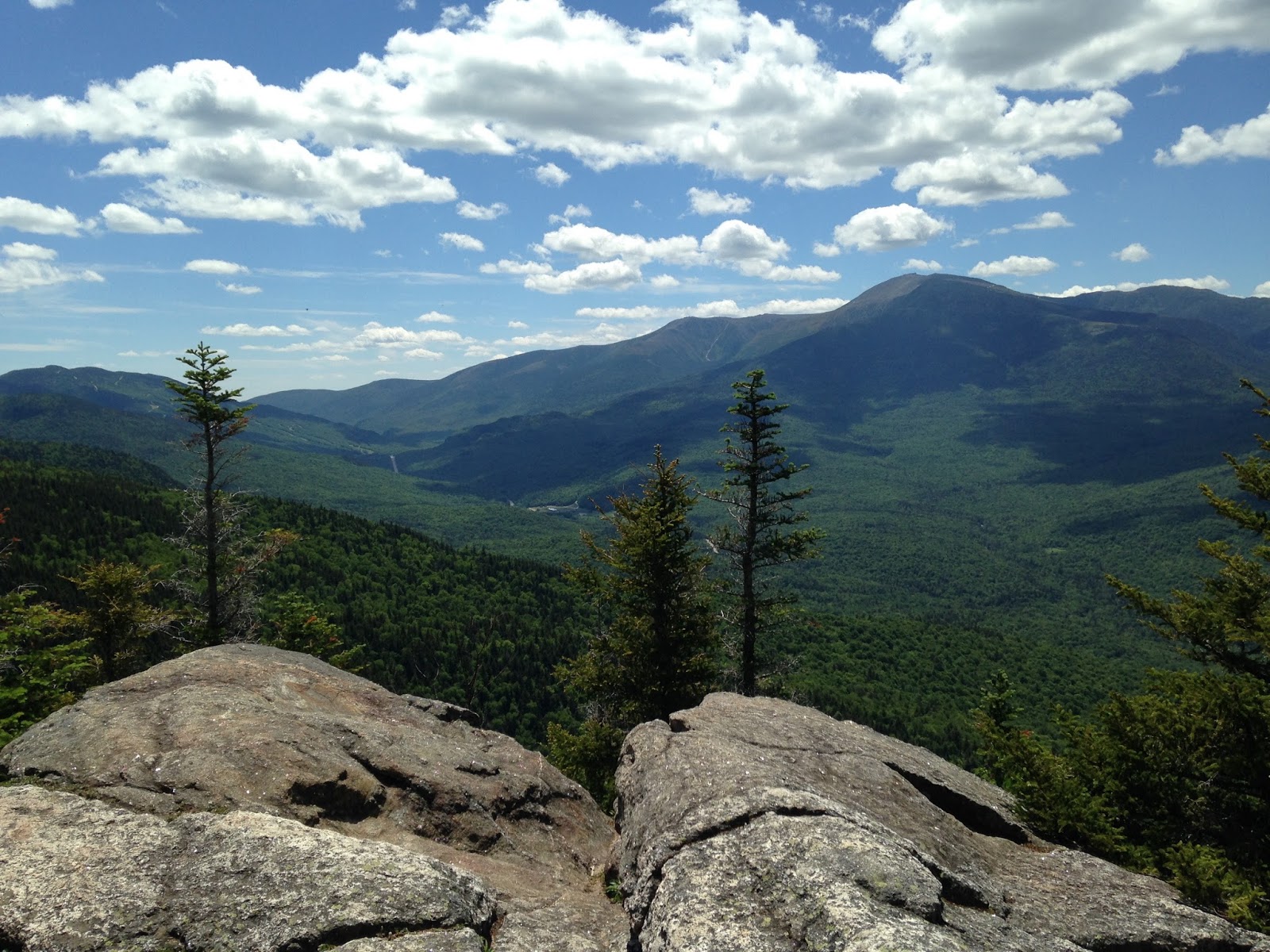
On the ridge from North Carter down to Middle Carter there are some GREAT VIEWS of the Wild River Wilderness (that is SUCH A COOL NAME!):


A "col" is a low point between two peaks. In today's case, it is a wet, boggy area at an elevation over 4000 feet! both in the woods

and in the open:


selfie on Middle Carter:

I don't know if anyone is counting, but only ONE 4000 footer left!!

Heading back down, there is a section on the southern part of Imp Trail that is REALLY WET:

yes, that is the "trail", just babbling away, and glistening in the sunshine.

All along the Imp Trail are these large pieces of beautiful birch bark


Back down on Route 16, I had a short 0.3 mile hike back to the car. The road went alongside the Peabody River (flowing north to the Androscoggin River):


Thank You God for a GREAT DAY! 11.43 miles in 5 hours 23 minutes, with an elevation gain of 3,494 feet!


I figured out how to get "Terrain View":


Thursday, June 16, 2016 (left home at 6 AM, home at 9:20 PM)
358 miles -- down into Boston, then up 95, then up 16 (12:30 at the trailhead)
11.43 miles -- hiking (5 hours 23 minutes)
3 1/2 hours to get home (including a Number 9 pocket at D'Angelo's in North Conway)

Music today was:

The Who - Live At Leeds (original album)

[loud rock music with my windows rolled down on the highway]

Gil Scott-Heron & Brian Jackson - Winter In America

[not-so-loud while driving in traffic on Route 1]

Lou Reed - Rock 'n' Roll Animal

[back to music on the open road!]

The Beatles - A Hard Day's Night

[looking for Patti Smith - Horses, but this "H" album caught my fancy; and it sounded GREAT!]

The Beatles - Revolver

[listened to it 3 times through - good music I want to keep in my brain]

Bruce Springsteen - Greetings From Asbury Park, N.J.

[after the hike, I wanted to hear the songs I sung to myself on the trails]

various artists - Pure Cool

16 jazz classics [not-so-loud music driving through North Conway and Conway]

misc. B-sides from Bruce's singles, collected on Tracks


last 5 songs on Born To Run

Backstreets, Born To Run, She's The One, Meeting Across The River, Jungleland
[EXCELLENT!! Brings back the transcendent moment of Clarence blowing his sax on the Jungleland solo at Giants Stadium - Caroline had gotten us 3 tickets for July 27, 2008]

Shameless Plug: if you enjoy this blog, you may like my other one about Art Museums and National Parks (on May 2, 2016 I finished a 4-day trip to NJ-PA-VA-DC)
hyperlink: dixonheadingwest
http://dixonheadingwest.blogspot.com/

Friday, June 10, 2016

My 43rd (Zealand Mtn), Mount Guyot, 44th (West Bond), 45th (Mount Bond) and 46th (Bondcliff) 4,000 footers!

This is my first trip this year back in the Pemigewasset Wilderness (the area between the Franconia Range on the west and the Presidential Range on the east. Today's peaks (Friday, June 10, 2016) - Zealand Mtn, West Bond, Mount Bond and Bondcliff - are in the red square:

I did the others in 2014 and 2015. I have been thinking about this for the past year (I did Owl's Head 11 months ago), so let's get going!

Wendy will be joining me for the first 2.7 miles - a nice (easy) hike from the Zealand Trail parking lot up to Zealand Falls!! (along the right side of the map:)

I will then give Wendy a hug-and-a-kiss - she will head back to the car, and I will continue up past Zealand Falls Hut to Twinway Trail and "bag some peaks" in the Pemigewasset Wilderness!


It was a beautiful evening Thursday June 9 - our 37th Wedding Anniversary!!

Wendy and I had a nice dinner-by-the-Pemigewasset-River at The Country Cow in Campton, NH, and spent the night at the Day's Inn there. An early 7 AM breakfast at the Sunny Day Diner in Lincoln:


The Zealand Trail is a nice trail:

past pretty streams

and a very nice beaver pond


We had some rain this past week, so the Falls were running nicely:


(aren't we matchy-matchy in our red fleeces)


Zealand Trail connects with Twinway, which crosses the river, heading south. After crossing the river, the trail "goes up for a while" in forest. It is beautiful when it breaks out:


I headed down the side-loop for a View. Um, not much of a "View":


I did have a wonderful time at Zealand Pond:


Made my way up and over to the Zealand summit:


Keep hiking, and the sky clears (somewhat) to see Mount Guyot:


Mount Guyot is not an official 4000-footer because there is not enough up-and-down between it and the surround peaks. But (rumor has it) it has great views!

It is nice hiking through the high-ridge-woods:


I took the .5 mile side trail to West Bond - quite a group up there:

windy - foggy - no view.

I was down to 17% battery, so I plugged in my extender - I did something wrong, so it died at 10 miles right at Mount Bond:


Since Wendy picked me up at Lincoln Woods down on the Kancamagus Highway, and the only way to get there is over Mount Bond and Bondcliff, these photos will have to do:


There are a number of blogs out there with descriptions (and pictures) of Mount Bond/Bondcliff, and I agree with their experiences. The clouds started clearing as I went from Mount Bond to Bondcliff, and the trail up to Bondcliff is above the treeline, so when the views come, they are REALLY COOL!! I do want to go back someday.

Um, when I lose battery power, I also lose the time. With 5 miles to go, 2 guys coming up told me it was 5:25, so I really booked it down to Lincoln Woods to meet Wendy at our scheduled 6:45. I figured I was late, but the Rangers told me it was only 6:05!!! (so the 2 guys were off by an hour - 4:25, not 5:25). Bring a watch next time (and figure out the battery-extender)

Wendy was in the lot at 6:25, burgers at the bar at Black Mtn Burgers, and home by 9:30 - WOW - Thank You God for a GREAT DAY! 20 miles in 9 1/2 hours!

Shameless Plug: if you enjoy this blog, you may like my other one about Art Museums and National Parks (on May 2, 2016 I finished a 4-day trip to NJ-PA-VA-DC)
hyperlink: dixonheadingwest
http://dixonheadingwest.blogspot.com/