
We met at Katahdin Stream Campground at 8 AM, and headed up Hunt Trail.
Wendy and I spent the previous night at Katahdin Inn & Suites, and I purchased the (waterproof) Trail Map when I made the parking reservation for Thursday's hike - Baxter State Park likes to have hikers and campers use their reservation system, even though I had no problem entering/parking on my Knife Edge hike Thursday Aug 4:

I had a beautiful view of Mt. Katahdin on my morning drive:

the forecast was 50% chance of showers, but the sun seems to be breaking through.
The morning lakes in Maine are pretty awesome!:


The cute morning hikers ready for their final day!:

About 1.2 miles up the Trail are the Katahdin Stream Falls:


Deede and Tad are Very Good Hikers - splits for the first 2 miles were 25 minutes and 33 minutes. I trailed them and was able to keep up. The first breakout is a beautiful view across Witherle Ravine at The Owl (3736 feet):

Once we got above the treeline, the hike got exciting:

Baxter Peak is off to the right (out of the picture); it is a beautiful day, with the clouds coming and going.
Looking back down from the top of the trail in the above-photo:

4 miles up the trail (1 1/2 miles from the top), the trail levels out, but the clouds come-and-go:

And then they hit Baxter Peak - The End of The Appalachian Trail:


Nice of The Kids to let The Old Guy tag along!
Of course, there are GREAT VIEWS:


(can you see the orange hiker?)
It was Quite A Party Scene up there on the Mountain!

Great Views going back down:
looking down on The Owl:

Scrambling down through The Gateway

Katahdin Stream down at the bottom:

Tad and Deede traded in their Day Packs for their real packs, and that marks the end of this "Great Adventure"

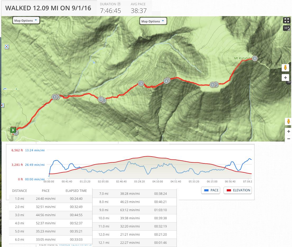
Thank You God for a GREAT DAY! 12.09 miles in 7 hours 47 minutes, with an elevation gain of 3,984 feet!
Thursday, September 1, 2016
8 AM at the trailhead
12.09 miles -- hiking (7 hours 47 minutes)
331 miles - 5 1/2 hours to get home (Wendy driving almost all the way because I was EXHAUSTED)
Shameless Plug: if you enjoy this blog, you may like my other one about Art Museums and National Parks (on July 23, 2016 I finished a 6-day trip to Indiana/Kentucky/DC/Connecticut)
hyperlink: dixonheadingwest
http://dixonheadingwest.blogspot.com/