Friday, October 26, 2018

NE 100 Highest (#98) - East Kennebago Mtn, Maine

Friday, October 26, 2018 - After another GREAT Breakfast at "The Looney Moose", I headed down the road. 10 miles later I turned off State Hwy 16 West, at Langtown Mill:

I took a right off the blacktop, and drove on the bridge over the Dead River:


After the bridge, you take a quick right and drive a dirt road with HUGE POOLS OF WATER - they might be frozen, they might not be frozen - they might be shallow, or they might be VERY DEEP. You take it VERY SLOW and stay as far to one side or the other as you can:

Once snow covered the road, I followed car/truck tires up. Because I thought "They must know where they are going", I mistakenly continued straight at one point, when I should have taken a hard left uphill. On my mistaken straightaway, I finally parked where there was enough space, and before the road "got bad":

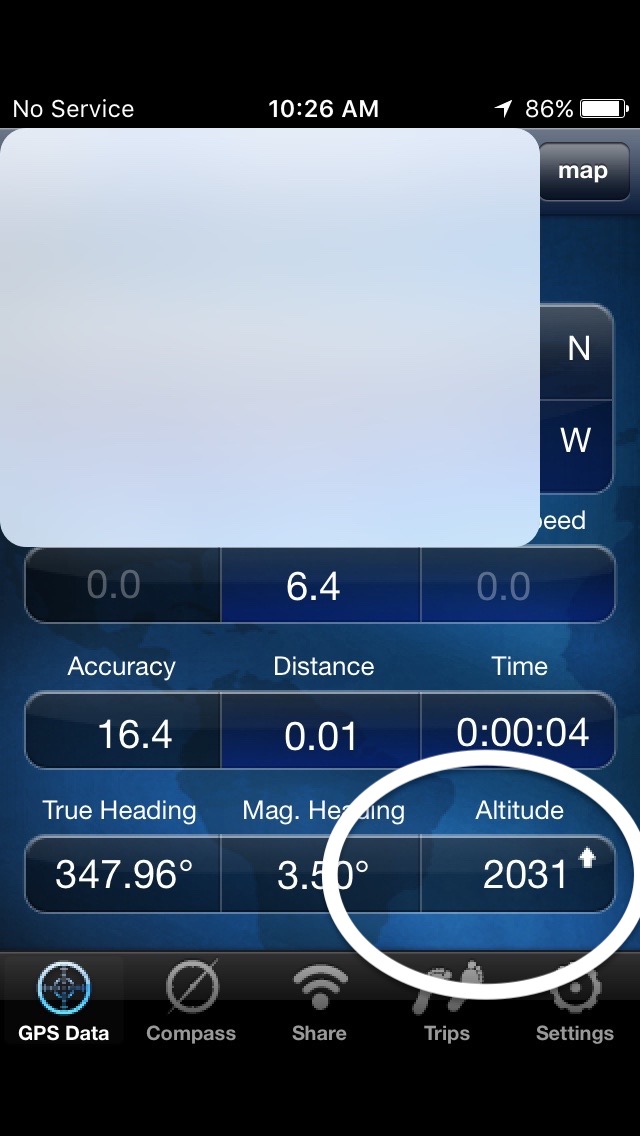
I started hiking up this road around 9:30, expecting it to "go up" and turn into a trail. It didn't. After 30 minutes of relatively flat hiking, I pulled out my iPhone - one of my apps has "altitude", and I wanted to be up around 3000 feet. Um, I was actually around only 2000 feet:

So I headed back to the car - a very nice 3 mile hike in just about an hour. Fresh air, sunny day, get the body moving. And this is how my "lower hike" compares with the Real One:


Once I turned around and drove back, I easily identified "the correct turn":


I drove up as far as I was supposed to. This looks back down the road:

Over the car at the beautiful view:

And looking up my path-to-be:


The trail started out wide, with another set of footprints coming down - I guess they are leftover from yesterday:

After a while, it narrowed to a path:


After 0.98 miles I came to where I was supposed to turn left into the woods. I had previously printed 3 versions of what today's hike would look like:

There are 3 parts:
1) the mile northeast uphill on the road/trail,
2) a sharp-left cutback through the woods (marked by a piece of wood painted yellow) - straight path, and marked by yellow blazes on the trees (1/3 mile?, ?1/2 mile?)
3) when you get to the yellow-and-blue blaze on a tree ("top of high ground on the trail"), take a right and go up for the summit.

I used my Spidey-Sense a lot today. Going up I kept looking to my left, and it was just thick woods - until suddenly it wasn't:

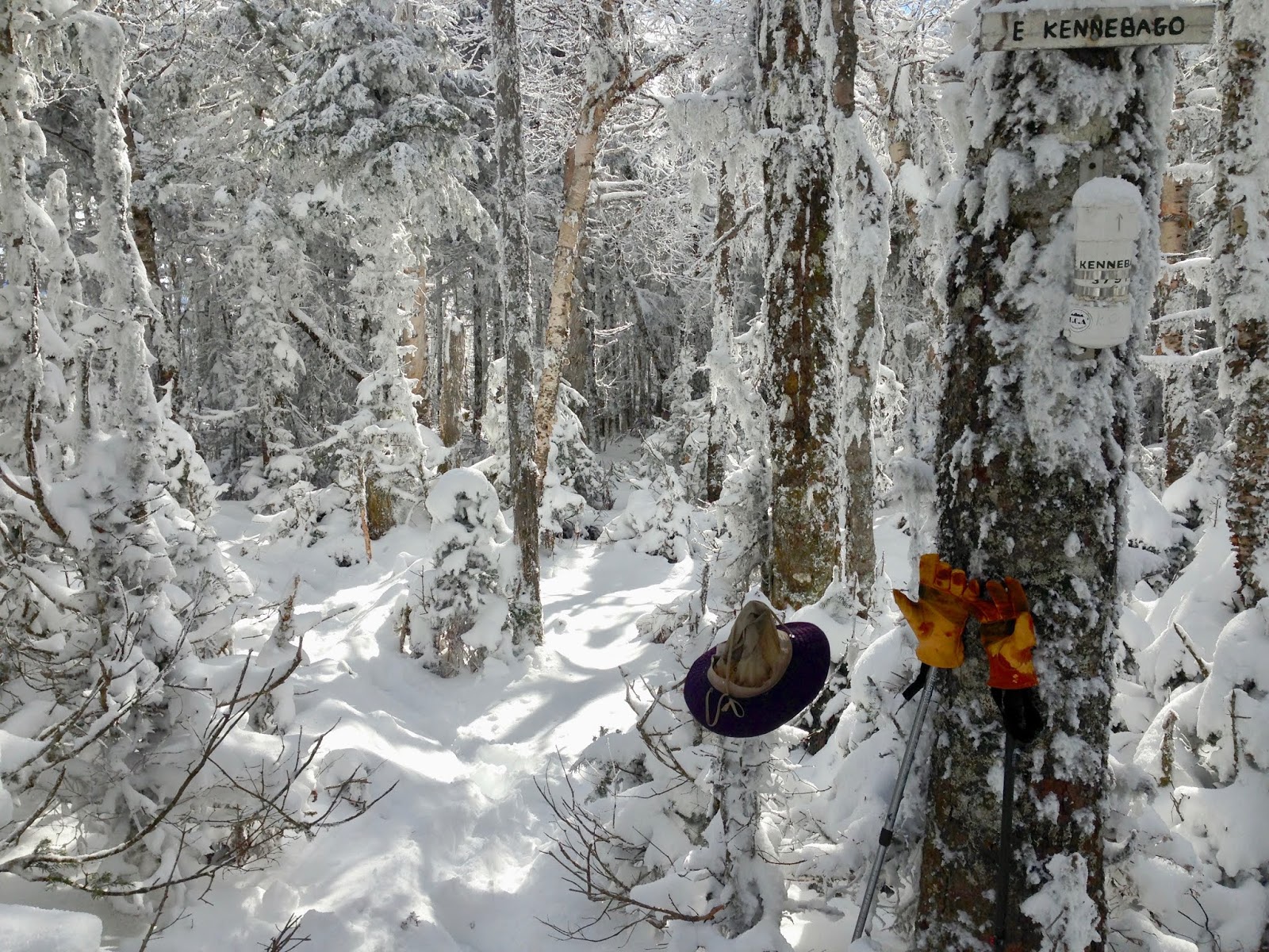
The yellow piece of wood was laying down, with snow on top of it, but I could see a little yellow on its underside (I cleaned it off and propped it up better). The trail was OBVIOUS:

and that's OK with me. It wasn't as straight as I had been led to believe, but it is really the only way through these thick woods.

20 minutes, and 1/3 of a mile later, I was standing on the path, with a gut sense that the tree-with-the-yellow-and-blue-blaze should be around here somewhere. So I poked at the snow on the tree in front of me and VOILA - HERE IT IS:

As Lefty Gomez, who played for the Yankees in the 1930s, said: "I'd rather be lucky than good".

I was pleased to see a trail going UP, although not as straight as the one I had just been on:


There were twists and turns, and A LOT OF SNOW:


but 30 minutes (and 1/2 mile) later, I was at the summit of East Kennebago Mtn:


I walked around at the top, and the sky was SOOOOO BLUE:

Did I mention there was snow in northwest Maine?


Going back down WAS A BLAST! With my LL Bean rubber soles, I slid/boot-skied almost all the way down. Very Fun! It took me only 45 minutes to get back to the car (1:30 to get up). 4.3 miles later I was back on blacktop! Wonderful drive back down 16 West (in Maine), which turns into 16 South in New Hampshire. I wanted to stop for pictures many times, but only really did at Chocorua Lake in Tamworth, New Hampshire:


Wow - so this is what "October" is supposed to be like! Pretty nice!

Back in Massachusetts, I didn't want to just bang the corner (go down 95 and then up 128) - it is the Friday-before-Halloween, and I imagine there will be A LOT of traffic to Salem. So I cut over on 133 and went through Rowley, Ipswich and Essex. Home around 7:15 - Thank you GOD for all these Great Adventures (only 2 mountains left!)

Today's music:

Laurence Juber - LJ Plays The Beatles!, 2000

wonderful acoustic guitar renditions of 14 Beatles songs.

Chris Whitley - Living with the Law, 1991


The Beatles - Magical Mystery Tour, 1967


Linda Ronstadt - Living in the USA - record, 1978

I have on my iPod the 2 sides I ripped from the original record (side 1 and side 2). It sounds lush and full. I just ripped it as a cd, and I'm interested to see if I can hear any differences - a nice little audio adventure.

various artists - Living In Oblivion: The 80's Greatest Hits, Vol. 2


The Doobie Brothers - Livin' On The Fault Line, 1977


Jackson Browne - Lives In The Balance, 1986


J. Geils Band - "Live" Full House, 1972

WOW - WHAT AN EXCELLENT LIVE ALBUM!!!

Neil Young - Live Rust, 1979 double live album


Thursday, October 25, 2018

NE 100 Highest (#97) - White Cap Mtn, Maine (3856')

Thursday, October 25, 2018 - It is always nice to spend the night in the area I'm going to hike - no "hours of driving" before I get to the trailhead. Having said that, this morning's drive might be longer than the milage would indicate:

It looks like only 37 miles, but over an hour and a half of driving.

7:16 AM


I hit the road after a GREAT Breakfast at "The Looney Moose"! 7.3 miles north and that was my last glimpse of pavement until 6 PM tonight. 9 AM on "Tim Pond Road", heading west:

It was 28℉, at 9:49 AM - I thought it was supposed to "warm up" today.

I kind-of overshot my turn onto "Wiggle Brook Road", but was able to get back to it:

At 10:30, I ran out of road up on "Wiggle Brook Road":


So I headed back down, west on "Tim Pond Rd"/"Lincoln Pond Rd", and then north on yesterday's logging roads:

I'm starting to have a gut-sense that I might not get in all 3 mountains today. We'll see.

It was 25℉, at Noon, as I got to "Porter Brook Rd":

I parked at 12:30

My "plan":

was to park (red X), hike northeast-east (following a road/path), to the "top of the col", then turn south and hike south up the ridge to "Kennebago Divide". From there, hike directly North (downhill-then-uphill) up to "White Cap" peak, then West (down-and-up) to the US-Canada Boundary Swath, then north along the Boundary Swath to "Boundary Peak". Then backtrack, and go down west into the valley, and return to the car via roads. Nice Plan.

Although there was a clearing behind where I parked, it looked to be going kind-of south, so I started up the "trail" in front of me.

20 minutes later I was in the Snow and in the Woods:


20 minutes after that, I came out onto a clearing area, going up hill:

Wait Wait - I had read about a "mini Washington Monument" on the boundary-swath of the US-Canada Border!!! I had gotten distracted hiking, and wound up going NORTH (not EAST), and wound up here:

Well, I'm glad I brought my Passport:

Ok - since I am here, I could go North and bag Boundary Peak - but I didn't bring my "Boundary Peak" sign. I was planning to do the Kennebago Divide - White Cap loop, so now I'l just do it in reverse. So I headed East (that's White Cap in the distance, 1.5 miles away):

It was kind-of fun traipsing through the woods:

and making my way up one of those clear-cut areas on the west side of White Cap


Because of my mess-up earlier, I had the compass out every other minute, keeping EAST. At 2:30 (2 hours, 2.5 miles hiking), I was AT THE CANNISTER-AND-SIGN:


I kept following the path east, then down toward Kennebago Divide:

I was feeling pretty good, and intersected the "path" (with one set of footprints on it), and headed left/east. It was supposed to turn south and go up the mountain, but it just sort of disappeared. I continued through the woods, but there was no way I could tell where I was or where I was going:

I backed up, then went down another path southwest, but didn't get anywhere. I suddenly realized that it was 3:30, I was hiking in deep snow in the woods, and I wasn't having fun anymore. Time to head home!

40 minutes later I was back at the car:


It was a good trail to hike out on:


But it was COLD when I got back in the car:


On my way out, I turned north - I wanted to see what the "Border Crossing" was like. Well, just a little farther north, the bridge/road is washed out. Instead of repairing it, they (whoever "they" are) just put down some rocks so you couldn't drive into the river by accident:


It is going to be GREAT when I come back up here next year, in warm weather and sunshine (maybe stay with Mark and Betsy???)

I headed down the Logging Road, expecting twists and turns. I don't know what happened, but I came out on "Tim Pond Road" (with a sign for "Lincoln Pond Road") at "Kennebago River Kamps". WOW, and Weird. East on "Tim Pond Road" for 17.1 miles, back to pavement, then south to Stratton. Another nice hot bath and then dinner again at "The Stratton Inn". WOW - Thank you GOD for these wonderful adventures (I got one mountain under my belt)!

Today's music:

The Eagles - Long Road Out of Eden, 2007


Stills-Young Band - Long May You Run, 1976


John Fogerty - The Long Road Home, 2005


John Mellencamp - The Lonesome Jubilee, 1987


lyrics: "Hotdogs And Hamburgers "

Every one of us has got to choose
Between right and wrong
And givin' up or holdin' on
..........
So I drove down the highway
Till I came to Los Angeles
The town of the angels
The best this country can do
I got down on my knees
And I asked for forgiveness
I said, Lord, forgive us for we know not what we do

Tame Impala - Lonerism, 2012


The Clash - London Calling, 1979


Neil Young - Living With War, 2006