Wednesday, August 7, 2024 - This year's "Big Road Trip" is done, so I want to tackle an "Unfinished Hike" from last October. Last October there was bad weather (cloudy/rain - not very good for a hike "with magnificent views of the gulf and surrounding mountains"), and I ran out of daylight. "Great Gulf Trail" is on the Terrifying 25 list, which is a list of trails in New Hampshire that have what may seem to be some type of "dangerous activity" associated with them (rock slides, multiple ladders, etc). There are 20 "Required" Trails, plus you select 5-of-14 "Optional" trails.
I did such a good job writing the blog for last October 13, 2023 that I'll just copy the first section (before any photos):
On the map:
Yellow = "Required", have not climbed
Blue = "Optional", have not climbed
Green = "Have Climbed"
I have climbed 13 of them, and today is a trail just east of Mount Washington:
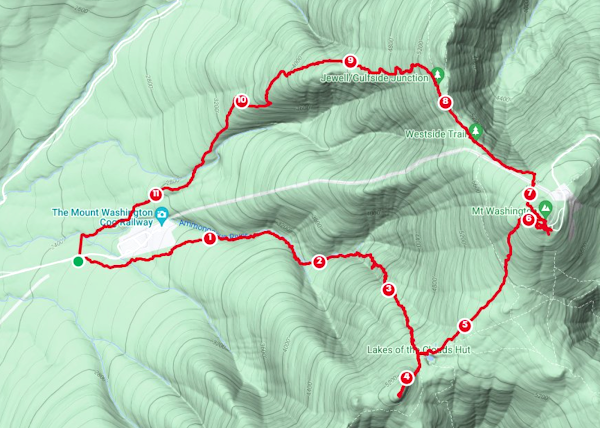
From the Parking Lot on Route 16, I'll be going west on Great Gulf Trail all the way to the summit of Mount Washington.
I already summited Mount Washington back on August 27, 2015 (read that blog here), but from the west side:
That day I started the hike in lovely weather, but the top was howling wind, in a cloud. I'm hoping for something better today.
According to the AMC Guide Book "White Mountain Guide", the trail is 7.8 miles to the summit, gaining 5,000 feet in elevation, and (generally) takes 6 hours 25 minutes:
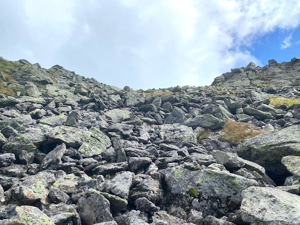
After Spaulding Lake, the description reads: "The trail runs south and then southeast, with magnificent views of the gulf and surrounding mountains, rising 1,600 ft. in about 0.8 mi. over fragments of stone, many of which are loose. Extra caution is needed in an area where the trail crosses a rock slide caused by the 2011 storm, where the footing may be especially unstable. The way may be poorly marked because snow slides may sweep away cairns. The trail generally curves a little to the left until within a few yards of the top of the headwall; then, bearing slightly right, the trail emerges from the gulf and ends at Gulfside Trail near the Cog Railway. It is 0.4 mi. from here to the summit of Mt. Washington."
I guess we know why it is on the "Terrifying 25" list!!!!
-------------------------
This is the description from the Terrifying 25 website:
-------------------------
Hiking-in-early-August eliminated any "Daylight-hours" concern, but I still need to learn more about THE WEATHER. It turns out that when you search "Mount Washington forecast", there is a sub-section relating to "The Higher Summits":
It is raining in Manchester, so I really like the part about "drier weather for northern areas", as well as "partly sunny skies"!
I left the house a little after 6 AM, and reached the Chocorua Lake area at 8:25:
I hit The Trailhead at 9:40
Fun Bridge over the Peabody River:
At 1 Mile (10:04 AM), heading up The Trail:
At 2 Miles (10:30 AM), heading up The Trail:
Quite Beautiful going up alongside the West Branch Peabody River:
At 3 Miles (11:10 AM), heading up The Trail - THIS MUCH MOSS means it is usually a VERY WET environment:
The Beauty of the West Branch Peabody River:
At 4 Miles (11:53 AM), heading up The Trail, with The River on my right:
At 5.13 Miles (12:38 PM) - for an early-August river, this is pretty awesome:
At 6.23 Miles (1:37 PM) - the beauty of Spaulding Lake - interestingly, it took me 30 minutes more today to reach this point:
25 minutes later, looking up, you realize ALL BETS ARE OFF WHEN "THE TRAIL" can include A STREAM/WATERFALL:
But looking backward, down into the Great Gulf Wilderness, is PRETTY COOL:
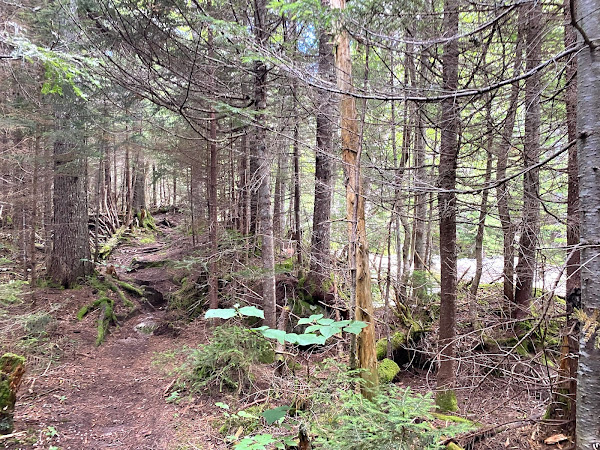
At least there are Trail Blazes:
At 3:25 in the afternoon, I'm still climbing up, hand-over-hand, one-step-at-a-time:
The Mountain I AM NOT GOING TO (Mount Clay) and The Trail I AM NOT GOING TO TAKE (Sphinx Trail):
My Finale, with Mounts Jefferson, Adams and Madison in the background:
20 minutes later (4:02 PM) at THE SUMMIT:
So, when I took that Summit-selfie, my phone battery was at 1% (I brought my battery charger, but forgot the cable). I stopped MapMyWalk and saved my workout. I had hiked 7.56 miles in 6 hours 21 minutes, and I was wiped:
Since I WAS NOT GOING TO HIKE DOWN ANY HIKING TRAILS, I hiked down the Mount Washington Auto Road and the up Route 16 to my car at The Trailhead - 9.2 miles:
Don't know, but Maybe I'M DONE WITH GREAT GULF WILDERNESS. The "Terrifying 25" list includes 3 other trails in the Great Gulf Wilderness: Sphinx Trail, Six Husbands Trail, and Madison Gulf Trail:
The List also includes Huntington Ravine Trail up Mount Washington - its description is:
When I finished around 7:30 PM, I had done 16.8 miles in 10 hours. That was a really hard day (but I recovered very well, fyi). Once again, it all looks pretty cool in Google Earth:
Home by 10:10. Thank You God for this wonderful ADVENTURE DAY!
For my listening pleasure today:
Counting Crows - July 4th Spectacular, released July 4, 2014, last heard 3/04/2016 - Free download with 10 tracks from their 2014 shows:
various - 80's Dance Floor, 2006 album, last heard 3/05/2016 - interesting collection of 6 studio cuts and 4 live cuts:
Michael Franti & Spearhead - Everyone Deserves Music, 2003 4th album, last heard 2/17/2017:
Jamie Cullum - Momentum, 2013 6th studio album, last heard 2/22/2017 - nice album of Jamie Cullum songs - I'm a fan, so I like it:
Hot Tuna - The Best Of Hot Tuna (2 cds), 1998 double-album, last heard 2/24/2017 - I love "acoustic Hot Tuna", along with some songs from their "electric phase". On a song-by-song basis, all songs are good, but best taken in small doses:
Bruce Springsteen & The E Street Band - 1975/12/12 Greenvale, NY - 18 songs, 2+ hours. This is one of my favorite concerts - I was there! "Santa Claus Is Coming To Town" came from this show. This was my 5th Springsteen concert:
Shameless Plug: if you enjoy this blog, you may like my other one about visiting Art Museums and National Parks (and hiking in the Rockies)
hyperlink: dixonheadingwest
http://dixonheadingwest.blogspot.com/


No comments:
Post a Comment