
The Dix Wilderness (Grace Peak, South Dix Mtn., Macomb Mtn., Hough Mtn., Dix Mtn.) on Monday; and Santanoni Peak/Couchsachraga Peak/Panther Peak on Tuesday.
Um, Wow, that does sound like a lot. But I ended my last trip up here with a wonderful hike up Seymour Mountain, so I'm excited to be back.
Sunday afternoon: Down 128, then up 93 into New Hampshire, northwest on 89 into Vermont, then over into New York State and the Rodeway Inn in Lake Placid (paid for with points!!):

It was another beautiful day in Vermont - no time for pictures, but I saw a Brilliant Emerald Green field, and then a Beautiful stream (I'll stop for pix next time).
281 miles today, checked in about 7 PM - Thank you God for a great drive!
I like starting the drive off listening to books-on-tape. Neal Stephenson (a sci-fi author I really like) wrote one of his early novels Snow Crash in 1992, cd 5:

then "music I don't usually listen to" on my iPod:
Of Monsters and Men - Beneath the Skin, 2015

Of Monsters and Men - My Head is an Animal, 2011 debut album

I really like this "Icelandic indie folk/rock band", and will keep them in my collection.
Ozomatli - Ozomatli, 1998 debut album

Ozomatli - Live at the Fillmore, 2005 live album

Ok, so I'm not really a fan of their "primarily Latin, hip hop, and rock music", and will not be keeping them. (Although they remain in some of my compliation cds: Hear Music Volume 2: Songs For Long Narrow Stretches, and Latin Groove, plus the 2 "Warren Miller soundtracks" I made: WM_Impact, WM_Journey)
----------------------------
Monday hike: This morning it is a 30-minute drive to get to the Trailhead Parking:

When all was said and done, I started hiking up the (TOTALLY UNMARKED) trail at 7:01 AM, right across from where I parked:

These 5 peaks in the middle are the ones I am interested in:

I have been doing A LOT OF RESEARCH on how best to do this. The first thought was to come in from the northeast on Trail 46 ("Dix Mt. from NY 73"), go up and bag the peaks along the ridge-line, then go down and back out the valley. But then I learned about the southern entrance - go in and park at the "Elk Lake Parking Area" (the upper yellow circle):

Unfortunately, because of COVID-19, the "Elk Lake Parking Area" (associated with the Elk Lake Lodge) is closed. The next-nearest parking area is at "Clear Pond" - 2 miles farther south (the lower yellow circle). I really don't want to add 4 miles to an already-long day.
So then I looked at the "northeast" map again:

and I saw that - maybe - I could go in along the South Fork Boquet River, up to Grace Peak, bag the rest, and go out Trail 46. Then walk down the highway to my car:

Nobody gives any milage figures, but I figure about 20 miles, and budget 10-or-11 hours.
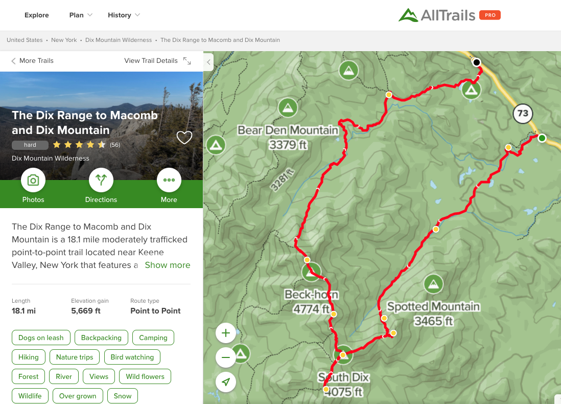
AllTrails Pro has a nice graphic/map:
and, yes, everyone says IT IS HARD.
I found a nice blog about going "up the ledges" to Grace Peak, so I knew "it could be done". Google Earth shows (looking west) me starting just north of "South Fork Boquet River", then crossing over to pick up the "main trail" (there was no parking available at that trailhead):


Very pretty walking up alongside the river:

After 35 minutes, you get a beautiful "break-out" view of the river and [some mountain]:

The trail became really hard to follow/find northeast of Lillypad Pond:


and I wound up doing some bushwacking around the north side of the pond/marsh.
I knew I wanted to be a little more north/right, and I got BACK TO THE TRAIL at 8:13 AM

I don't know why I lost it, but I'm not about to go back and find out. Bushwacking-pace is about 32 min/mile, while trail-pace is about 22 min/mile.
10 minutes later I passed a beautiful clearing:

and at 10 AM I reached the first-of-the-ledges:


Blessedly, there had been no rain last night, or yet today, so the rocks were dry - the trick was to avoid the streams/runoffs, and to figure out the best way up (line of least resistance):

I am able to change the date of the imagery, so here is a better look from 12/2013:

It took me a little less than an hour to reach the top:

and looking over at Hough Peak and Dix Mountain (in the cloud):

I went back-and-forth along the ridge-line, but there was no sign/no marking for Grace Peak:

Cool views heading down from Grace Peak, showing Macomb, South Dix, Hough, and Dix:

and looking down into the ledges that I climbed up:

Now to just make my way over to South Dix. Except, in keeping with the "no signs/no maintenance/no nothing" philosophy that is apparent throughout A LOT of this region, I "lost the trail" and spent time just wandering around:

The occasional cairn is VERY HELPFUL, but it really does take all of God's Grace to keep me on track.
After seeing some pretty flowers:

I made South Dix at 12:12


There is a MAJOR ROCKFACE going down from South Dix into the col:

I dropped my backpack down in the col, and went up Macomb:


(yes, USGS misspelled "MCCOMB". Macomb: after Alexander Macomb, who was a land speculator in the Adirondack region in the late 1700's. At one time he held title to a whopping four million acres. In comparison, the State of New York owns 2.5 millions acres in the Adirondacks today.
I've been at this for just about 6 hours, and I'm as far south as I'm going - time to retrace down-and-then-back-up (almost to the South Dix summit), then continue on the herd path north to Hough Peak.
and this is where MapMyWalk got a little funky (well, A LOT FUNKY!!):

I did not really "go straight" - MapMyWalk froze/rebooted/something, and kept starting/stopping:

It was really hard getting to the top of Hough Peak - there were a couple of "false peaks" (which don't seem so "false" when you are climbing them!), and the "herd path" was only about a foot wide. This means that you are constantly walking through branches (on both sides), that are wet from the rain that came through an hour ago. Looking back from one of the "false peaks":

Looking south, I LOVE the cloud that is caught on the east-side of the ridge!!
Hough Peak at 2:38 (with a fellow hiking-buddy - I ran into about a dozen people throughout the day):


It was really hard going up to Dix (does anyone see a pattern here?), especially the area known as "Beckhorn" - to get up a sharp crevasse between two rocks I had to position my knees against left-rock, and my fanny against right-rock, and then alternately scooch back-and-forth to get up. People behind me had a big dog, and I have no idea what they did.
Ok, so I'm climbing/hiking along the ridge, and I see a chunk of metal coming out of the rock above me. These mountains (and the ones in New Hampshire, and the ones in Maine) often have something random - mining tools, forest stuff, fire tower remnants, etc, so I didn't think anything of it. A little while later I noticed that I was following yellow blazes on the rock/ridgeline - "they" ONLY BLAZE "real trails", which means that "somewhere back there" I had transitioned from "herd path" to "real trail" (Trail 46, to be exact). So I back-tracked to find the "tiny USGS marker" I had read about - no sign/nothing else:


It's 4:02, and none of this is very satisfying.
Looking southwest, with Elk Lake in the distance:

looking west at various mountains:


looking northwest at the ridge-to-come:

and looking northeast back down into the Valley:

So, its just after 4 PM, and I'm on my way home. Smooth sailing from here (ha ha). 30 minutes later I was back DOWN at the intersection of Trail 46 and Trail 119:


Only 6.4 miles to Route 73, at 4:30 - ouch, its looking like a 12-hour day.
OH MY GOSH - the next 2 MILES were practically STRAIGHT DOWN - VERY dangerous!! I dropped about 2,000 feet in the next 2 miles (50 minutes), and said HI to the 2 girls filling up water at the "Boquet River Lean-to". They said about 4 miles to the road, so I crossed the river and kept going down the trail. And then, a quarter-of-a-mile later, just east of "Dial Pond", I lost the trail. My maps/pieces-of-paper were wet and crumbling, and I didn't know that I should keep going north, and even turning west to cross a couple of brooks, before heading back east:

so, instead, I headed STRAIGHT DOWN THE RIVER:


It was pretty comfortable rock-hopping, and there were a lot of gravel/bare stretches - but also, once in a while, there was some knee-deep water. All I knew was that I was headed downstream and towards the highway, at 6:17.
At one point, the river made a sharp-left turn, so I went up-and-over a hill:

12 minutes later, the river turned right, and I didn't like that (THANK YOU GOD!!!!). I made my way over a creek, down and around a swamp, and headed back up into the woods, picking up the trail coming in from the left:


I was still about 2 miles from the highway, and the trail was lousy with rocks and roots. I went past "Round Pond" at 7:30

It was a little hard to appreciate after 12-and-1/2 hours of hiking.
And it wasn't over yet:

As I was going around "Round Pond", I came to a small clearing with trails going off left, straight ahead, and down to the right. I could see that the one to the right just went down to the Pond, so that one was out. The trail to the left had a big log/tree across its entrance - this usually means "Old Trail - trail closed", so I continued down the one straight ahead. Imagine my surprise when I came upon a couple at a campsite, having dinner around a fire!! They told me I should have taken the left-trail to get back to the highway. So that's what I did. (oh, by the way, THERE ARE NO SIGNS ANYWHERE!!!!)
I hit the highway at 8 PM, and 30 minutes (and a mile-and-a-half) later, I was BACK AT THE CAR! Sunset was 8 PM, so there was still enough light to walk down the road. When all was said and done, I hiked maybe 19 miles in 13 hours 30 minutes:

I had plenty of food and water.
I really don't like getting lost - I'm pretty smart, and "woods-aware", so it really takes something bad to mess me up. And it happened THREE TIMES today!
I really don't like today's trails, both the "real trail" as well as the "herd paths".
I really don't like mountain peaks without a sign, or even any marking whatsoever!!
Getting rained on is ok, because I'm working - like getting rain during crew practice.
My Hulk t-shirt is now all ripped and torn, and will be in the trash when I get home.
With 5 peaks bagged today, I don't know if they will be the last of the Adirondack High Peaks...
As I mentioned, my papers got kind-of destroyed:

A 30-minute drive back to the Super 8 in Ticonderoga (paid for with points!!). Turkey sub for dinner. 64 miles driving today.
A nice phone call with Wendy, a hot bath, and then Lights Out - Thank you God for Helping me through all these Adventures!
Monday morning drive to the trailhead:
Charlie Parker - Verve Compact Jazz, 1948-1953 recordings, released 1990

I like listening to music while I hike, so we're going to try the boom cube and my 4-gig Gigaware player:

It is loaded with 66 mp3s ripped from "Whatever: The '90s Pop & Culture Box" - wow, really great music that gets you up and going. I listened to it twice through before the batteries died.
and then the Monday evening drive to the Super 8:
various artists - Chicago Blues Anthology, first album of a double-album release

really cool stuff!
No comments:
Post a Comment