Another list I got exposed to over the winter is the "Terrifying 25" - the list dedicated to climbing the scariest of New Hampshire's trails.
website
Well, it does sound like fun!
They say that you should hike a specific 20, then any 5-of-the-remaining-14. I think that for today I'll hike the "Morgan-Percival Loop", down near Squam Lake:

I went up 93, east on 3 (the New Hampshire Lakes look beautiful):

and got to the Mt. Percival Parking Area a little after 10AM:

My plan was to go around on Morse Trail, up Mount Morgan Trail, northeast on the Crawford-Ridgepole Trail, then back down on the Mount Percival Trail

This way, I can bag TWO on the list - Mount Morgan Trail:
"involves climbing over several ledges, passing through a boulder cave, and scrambling up three ladders and some ledges; Mt. Morgan is typically combined with Mt. Percival for a classic 5.4-mile loop; don't miss the boulder caves on Mt. Percival"
and Mount Percival Trail:
"climb through a small boulder cave; typically combined with Mt. Morgan for classic 5.4 mile loop; it can be tough to find the boulder cave loop from the summit as there is no sign near the summit"
A little ways from the parking area, you take a left onto Morse Trail:

It was a beautiful day for a hike in the woods

and an hour later I intersected the Crawford-Ridgepole Trail:

Turn right for 1/10th of a mile, then left for "The Cliffs":

pretty tricky going up the trail:

and then you get to the REAL TRICKY PART!!
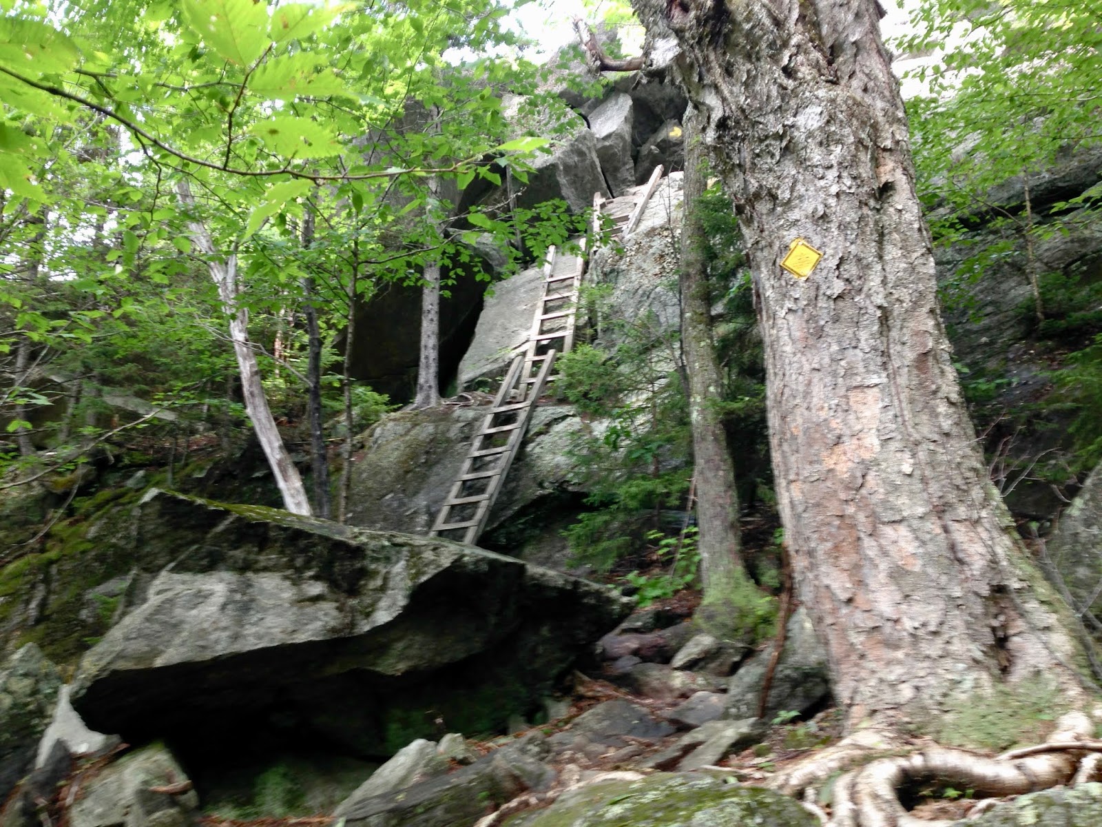
After going UP THE LADDERS (then through a "cave") (and climbing some ledges), you get to THE VIEW-POINT:


Continuing down-then-up on a side-trail to the summit:


looking north from the summit:

This is a good place to show my hiking map - 5.71 miles in 2 hours 55 minutes:

You can't tell, but I lost the trail and had to bushwack from Morgan to almost-Percival. The real trail is west of the ridge-line:

The forest wasn't bad, and I knew where I was going, so it worked out ok.
I was at Mount Percival by 12:15


A last look up at Mount Percival:

then down the ledge to find the boulder caves:

The yellow blaze on the granite wall means I'm on the right path:

You go down to the blaze, and turn right and crawl through a couple of boulder-spaces (having to take off my backpack both times to squeeze through!). But it was PRETTY COOL (not scary).
I then was able to just go bounding down the trail, passing people and having a great time - and making great time: 40 minutes for the bottom 2 miles.
2 hours to get home, by 3:30 - WOW - Thank you God for this Great "Terrifying 25" Day!
For today's listening=pleasure, I started with Neal Stephenson - Snow Crash, 1992, cd 3:

Then back to the mp3 cd that I burned back in November 2000:
Vineyard Sound - III, 1996

various Windham Hill artists - Winter's Solstice II, 1988

but I got tired of acoustic music on my drive home, so I put on some rock-n-roll from my green nano (LOUD):
The Doors - Strange Days, 1967 second album

various artists - Time-Life Classic Rock: 1966 - The Beat Goes On, 1966

lyrics: "Daydream" by The Lovin' Spoonful:
"And even if time ain't really on my side
It's one of those days for taking a walk outside."
various artists - 45's On CD, Vol. 2: 1960-1966, 1966

Shameless Plug: if you enjoy this blog, you may like my other one about visiting Art Museums and National Parks (and hiking in the Rockies)
hyperlink: dixonheadingwest
http://dixonheadingwest.blogspot.com/
No comments:
Post a Comment